Washington County is where it’s at for A.T. hikers and other outdoor enthusiasts.
They say a journey of 1,000 miles – or in the case of the Appalachian Trail, 2,198 miles – begins with a single step. But at some point, even the hardiest hiker needs to take a break from all that stepping. And one of the best places to rest and recharge on the A.T. is Washington County.
Not only is Washington County widely regarded as one of the most hiker-friendly communities along the Appalachian Trail, the town of Damascus is among only three communities on the entire trail in which the A.T. passes directly through a downtown. As a result, businesses throughout the area, including in nearby towns such as Abingdon and Glade Spring, make an extra effort to welcome the travelers.
“Hikers are some of the best people you’ll ever meet,” says Ralph Wilson, who owns both Damascus Diner and Dragonfly Inn. “They’re very in tune with the environment. When they say leave no trace and have no worries, those are not cliches to them. They live by it. They may be a little dirty and smelly when they get here, but when they leave, we make sure they’re all good.” One way Wilson does that is by offering hikers what he calls “trail magic” in the form of cookies and brownies…
…Whether hikers are making a brief stop while passing through or staying for a longer visit, there is plenty to see and do in Washington County. Here is a sample of what’s available. Consider it a step-by-step guide to exploring the region.
Get Informed
The new Damascus Trail Center, a collaboration between the town and the Appalachian Trail Conservancy, provides visitors with a wide range of outdoor resources available throughout the region, including information about area attractions, backcountry skills and trail conservation. “The Trail Center is able to highlight and amplify everything that we have around us,” says Julie Kroll, recreation program director for the Town of Damascus. “You can pick up local maps, find out about local activities and get local advice. It’s a great place for uniting visitors and locals and connecting them with our outdoor recreation resources.”
Stock Up
There are several outdoor stores throughout the region for replenishing your gear, including Damascus Outfitters. Adventure Damascus Bike Rental & Shuttle Co. is among the businesses that offer shuttle service to area trailheads. “We truly cater to outdoor recreation here and have everything that folks would need,” Kroll says.
Chow Down
A lengthy hike can certainly work up an ample appetite. The Damascus Diner serves tasty meals seven days a week, from eggs and French toast in the morning to burgers and veggies throughout the day. “Hikers aren’t shy when they come in to eat,” Wilson says. “Sometimes they’ll eat more than one meal at a time.” The diner neighbors coffee shops, craft beverage destinations and other local restaurants. Appalachian Heritage Distillery helps hikers keep their spirits up, highlighted by their award-winning vodka. And when it comes time to venture back onto the trail, you can pick up groceries at Food City.
Washington County celebrates the outdoors with the annual Appalachian Trail Days event, held in May. Known as a “tramily” (trail family) reunion, more than 20,000 people regularly make the trek to Damascus for three days of music, food and camaraderie.
“It’s one big celebration of the Appalachian Trail and hiker culture,” Kroll says. “It’s a chance to show what a friendly community we are, and how we’re all focused on the trails that pass through here.”
This article, All Hail the Appalachian Trail, was first published in the 2024 issue of Livability magazine. Sponsored by the Washington County Chamber of Commerce.Learn more at Livability Washington County.
Mountain Magic: Outdoor enthusiasts praise the region’s abundance of nature.
Washington County is a prime location for outdoors enthusiasts of all levels. At the intersection of several famous trail systems, the region is a desirable destination for anyone seeking to live closer to nature and be a part of a community full of adventurers.
As a lifelong Damascus resident, Michael Wright has made a living promoting Washington County’s outdoor wonders through his local businesses. He owns and operates Adventure Damascus Bicycles, Damascus Outfitters, and Trailhead Designs, as well as Hellbender’s Cafe on the Virginia Creeper Trail. The area’s prime location amid the Appalachian Mountains brings with it an abundance of outdoor amenities. Hikers can hop onto portions of the Appalachian Trail, which cuts through the area, or the Virginia Creeper Trail, offering over 34 miles of multiuse paths.
“Damascus is truly a haven for outdoor enthusiasts,” Wright says.
Appalachian Bound
Living among the natural beauty of the area has allowed Wright to build a life and career in the outdoors industry, from opening the first full-service bike shop on the Virginia Creeper Trail to a high-quality outfitter for Appalachian Trail hikers. “I have been able to create many jobs, make a living and raise a family in the small community I grew up in,” Wright says. “I have also felt that it was my duty to try and share the beauty of the area and help create some fun memories for as many visitors as I can.”
Damascus has become known as the “Friendliest Town on the Appalachian Trail.” This is due in part to the number of amenities for thru-hikers making the journey from Georgia to Maine. Damascus Outfitters carries all the essentials a hiker might need, along with fun souvenirs to remember the journey by.
The Damascus Trail Center, in collaboration with the Appalachian Trail Conservancy, helps educate visitors about the history and significance of the trail and Damascus’ role in stewarding the land.
Wright sees proximity to nature and outdoor opportunities as essential to the overall health of individuals and their communities. “Our walkaable communities and our local trail systems help to improve a person’s mind and body,” Wright says.
While the area’s natural beauty alone is enough to draw visitors, its hospitality is what makes people want to stay. The “Friendliest Town on the Appalachian Trail” doesn’t just cater to hikers. It’s for anyone with an appreciation and desire to connect with its natural abundance. “Washington County is not just a place to live – it’s a place to thrive,” says Wright.
Local Favorites
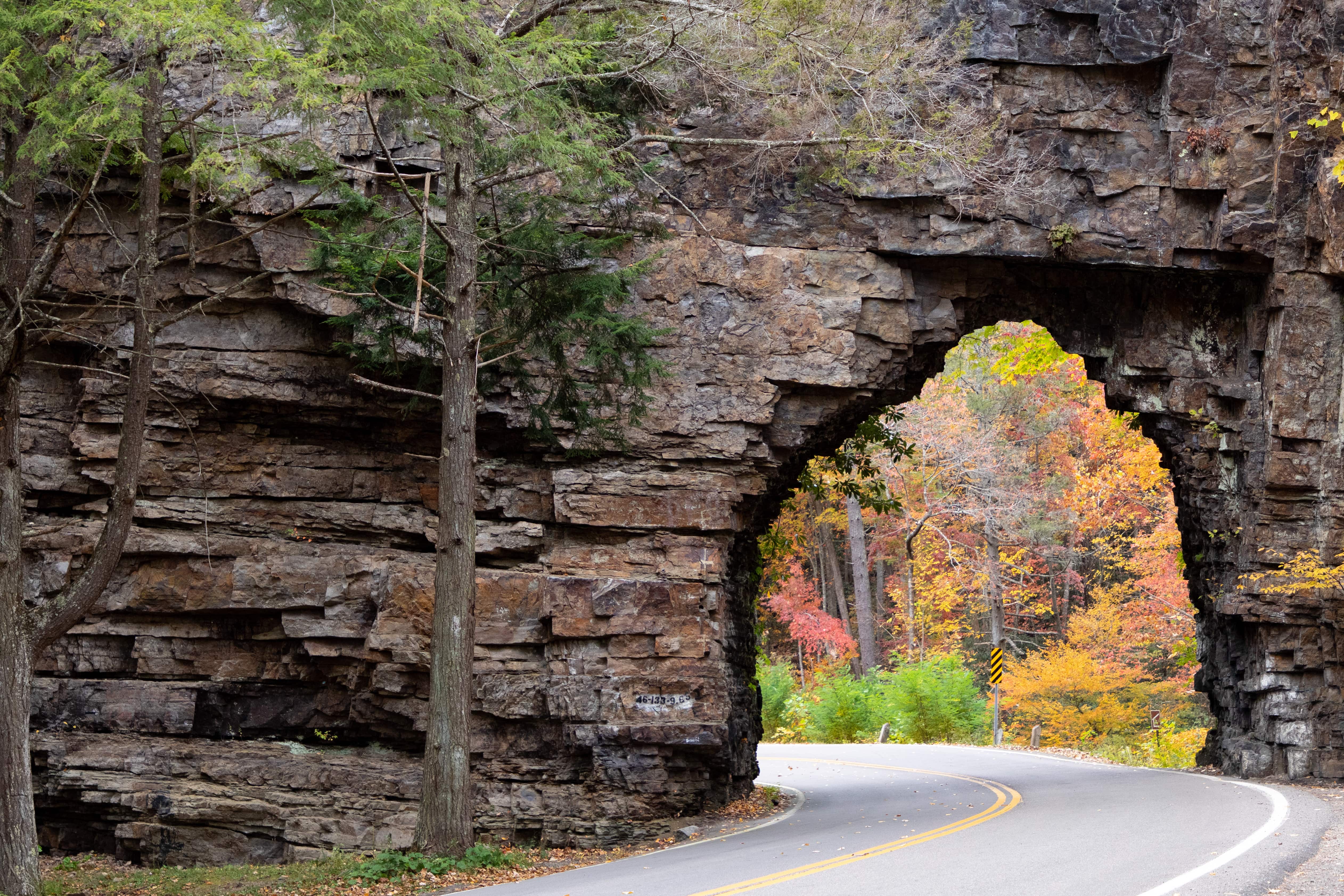
Mount Rogers is Virginia’s highest peak. The hike offers views not only of the surrounding mountains but of the wild ponies that reside there. Hikers can also enjoy a short trek to Buzzard Rock on Whitetop Mountain. For a fun bike trek, start out at Hellbender’s Cafe in Taylors Valley and ride to Straight Branch. Or, for an easy day out, Wright suggests a picnic at Backbone Rock.
Livability Magazine, Washington County
This article, Mountain Magic, was first published in the 2025 issue of Livability magazine. Sponsored by the Washington County Chamber of Commerce. Learn more at Livability Washington County.
Tips for the trail –All trails lead to Damascus, Virginia! We have hundreds of miles of trails for you to explore right in our backyard.
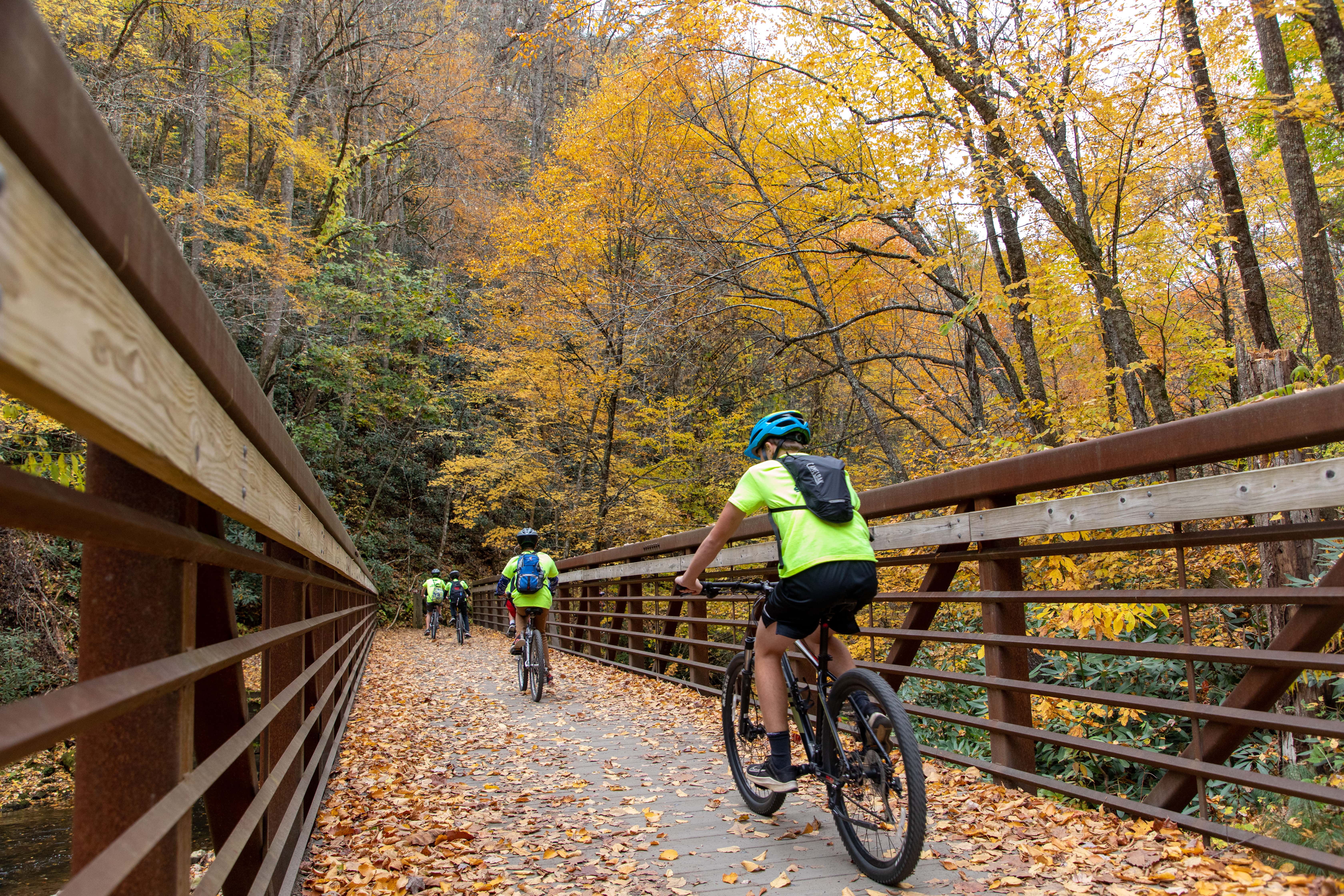
At the edge of town, Mount Rogers National Recreation Areastretches as far as the eye can see, across the highest peaks in the state, over mountain balds and spruce-fir forests, trout streams, and more than 400 miles of trail. Find paths less traveled in Cherokee National Forest just south of town. In the heart of Damascus, you’ll find the Virginia Creeper Trail, one of the most famous biking trails in the United States. Take a shuttle to the top and enjoy the scenic ride back down through the forest from Whitetop Station.
To make the most of your time on the trails around Damascus, VA, it’s important to be kind, be aware, and be prepared. Here’s some local advice:
1.) Trail Tip: BE Kind
Be respectful of other visitors and their experiences. (And remember, we are all visitors on the trail!).
Leave your bluetooth speaker at home and listen to the sounds of nature.
Leash and control your pets. Pack out pet waste.
Share the trail: Bikes should always yield to hikers and horses. Downhill yields to uphill traffic.
2.) Trail Tip: Be Aware
Safety first: Notice your surroundings. Always know your location.
Watch out for wildlife and give them plenty of space. Do not feed wildlife or leave food unattended.
Littering on trails is often accidental (at least, we hope!). If you bring something with you, pack it out too.
Reduce your impact by staying on designated trails, roads, and campsites.
In downtown Damascus, please walk bicycles when using the sidewalks.
3.) Trail Tip: Be Prepared
Know the weather forecast. The weather varies and changes more quickly at higher elevations.
Bring the essentials: clothing layers, food and water, navigation, and a first aid kit.
Don’t count on having cellphone service outside of town.
Make a plan with your group and stay together. If traveling alone, let someone know your trip plan.
Make theDamascus Trail Centeryour first stop downtown to pick up local maps, find must-do activities nearby to add to your trip itinerary, and learn more about hitting the trails responsibly.
Happy Trails!
Trail Alerts & Closures
Be sure to check for the latest updates on alerts and trail conditions around Damascus, Virginia. Know before you go.
We are thankful for the groups that spend countless volunteer hours in stewardship to help maintain our trails. We encourage you to support and join their efforts. If you are just visiting, we recommend connecting with your local trail clubs and organizations at home.
Get the latest trail updates for alerts and trail conditions around Damascus, Virginia. Know before you go. More information below on current conditions, including:
Virginia Creeper Trail: OPEN from Abingdon to Damascus
Virginia Creeper Trail: CLOSED upper half, set to reopen March 31, 2027
Appalachian Trail closure, detour, and shuttle options for 2026 season
New Burn Ban in Mount Rogers High Country
Beartree Lake Restoration Project in 2025-26
Feb-Apr: Virginia’s 4 PM Burning Law
This is Trail Town USA. Several major trails pass through the heart of Damascus, including the Appalachian Trail and Virginia Creeper Trail. Nearby are multi-use trails and motorized routes in Mount Rogers National Recreation Area, George Washington-Jefferson National Forest in Virginia, Cherokee National Forest in Tennessee, and Grayson Highlands State Park.
Although the upper half of the Virginia Creeper Trail remains closed in the 2026 season, Damascus has many miles of other open trails nearby! Make Damascus, Virginia your basecamp for adventure. Check out some of our favorites in the region, from Grayson Highlands State Park in Mouth of Wilson, to one of our other neighboring rail-trails, the Mendota Trail in Bristol.
Looking to put in some big miles? Set your sights on the Appalachian Trail, Grayson Gravel Traverse, Overmountain Victory National Historic Trail, or TransVirginia Bike Route.
National Forest Maps
No signal? No problem! The new National Forests and Grasslands app by the Forest Service features offline maps, safety alerts, and a comprehensive set of recreation sites and trails – all for free. Download maps before you go:
Half of the Virginia Creeper Trail is OPEN, from the Start to the Heart, Abingdon to Damascus, about 17 miles. Our bike outfitters are providing rental and shuttle services for the Abingdon to Damascus section. Now open to e-bikes as well!
The upper half of the Virginia Creeper Trail, from Whitetop Station to Damascus, saw significant damage from Hurricane Helene in September 2024. The trail remains closed until it is rebuilt and is set to reopen on March 31st, 2027. There is no access to the Virginia Creeper Trail past Damascus at this time.
Work Zone: Please be alert to signage and barricades on the trail, and respect trail closures, for the safety of both the public and work crews. Closed area strictly enforced.
View all Closed Trails & Developed Recreation Sites near the Virginia Creeper Trail
Closed Trails & Developed Recreation Sites
Virginia Creeper National Recreation Trail, Forest Service Trail (FST) 4575, from Trestle 16 in Damascus to the North Carolina-Virginia state line just past Whitetop Station
Appalachian Trail from Highway 58 at Straight Branch Trailhead to Grassy Ridge Road/VA 859 (Northbound miles 476.6.0 to 485.8)
Whitetop Laurel Fishing Trail (FST 4645)
Taylors Valley Spur (FST 4651)
Creek Junction Trailhead
Straight Branch Trailhead
Whitetop Station Parking Lot and Trailhead
Green Cove Parking Lot and Facility
The Whitetop Station Visitor Center and Green Cove Station Visitor Center remain closed as well.
Virginia Creeper Trail Set to Reopen March 31, 2027
The Forest Service has announced that the Virginia Creeper Trail is expected to fully reopen on March 31, 2027. The Virginia Creeper Trail is a backbone of the local outdoor economy. The trail brings thousands of riders, families and visitors to Damascus, Abingdon and communities throughout Southwest Virginia each year. Now residents, outfitters, and nearby businesses have a clear timeline so they can plan ahead for next year’s tourism season.
The Town of Damascus, Virginia was delighted to celebrate the groundbreaking of the upper half of the Virginia Creeper Trail, on December 18, 2025, alongside the US Forest Service, Kiewit Infrastructure South Co., the Commonwealth of Virginia, and many regional partners and community members. This day marked a significant milestone in our recovery from Hurricane Helene in September 2024. As Mayor Lamb says, “We’re coming back better than we’ve ever been!” A year from now, we look forward to celebrating the ribbon-cutting with you. In the meantime, half of the Virginia Creeper Trail remains open, from the Start to the Heart, Abingdon to Damascus.
Virginia Creeper Trail Rebuild Contract
Virginia Creeper Trail Rebuild Contract
The Forest Service announced the award of the design-build contract for the Virginia Creeper Trail to Kiewit Corporation of Peachtree City, Georgia. This contract is valued at $240,580,432.12. This is for the full rebuild of the devastated upper 17-mile section of the trail between Damascus and Whitetop Station. This section of the trail remains under strict closure for the duration of the construction period, until otherwise noted. Estimated completion in Fall 2026. (posted Nov. 6)
Further updates will be shared here as they become available. Kiewit plans to share regular updates on its project website as well, linked below:
There is an Appalachian Trail closure and detour just north of Damascus in 2026. This closed area is strictly enforced. The trail is closed for 9.2 miles due to construction on the Virginia Creeper Trail. The closure area goes from US-58 at Straight Branch Trailhead to Grassy Ridge Road/VA 859. (Northbound miles 476.6.0 to 485.8). US-58 roadwalk NOT recommended. The Forest Service and Appalachian Trail Conservancy have two recommended detours for hikers.
A.T. Detour & Shuttle Options
Long distance hikers can bypass the closed area via other trails nearby.
Northbound detour: Follow the Iron Mountain Trail from Damascus to the Flat Top Trail and Mount Rogers Trail. Reconnect with the Appalachian Trail at Deep Gap, 2 miles south of the Thomas Knob Shelter.
Southbound detour: Follow the Mount Rogers Trail. Two miles south of Thomas Knob Shelter, hike from Deep Gap to the Flat Top Trail and Iron Mountain Trail. Reconnect with the Appalachian Trail in Damascus.
Hikers can also arrange a shuttle around the closed section. Recommended shuttle is from Damascus to Grassy Ridge Road/VA 859 or to US-58 at Summit Cut.
With these recommended detour or shuttle options, hikers can still experience the beautiful Mount Rogers High Country. Additionally, the Iron Mountain Trail was originally part of the Appalachian National Scenic Trail until 1972. Historic shelters remain available for overnight use.
Important Notes for multi-use
Wear blaze orange. The Iron Mountain Trail is open to hunting. This includes the use of hunting dogs.
Sections of the Iron Mountain Trail are multi-use. Stay alert and share the trail. Mountain biking, equestrian, and motorized use are allowed in some areas.
Note: This trail closure is partway between Damascus and the Whitetop Mountain/Elk Garden area. Hikers traveling between town and the Mount Rogers High Country must plan an alternate route for the 2026 season.
The Forest Service has issued fire restrictions for the Appalachian Trail through the Mount Rogers High Country. This burn ban is from Beech Mountain Road to Massie Gap (NOBO mile 489.4 to 502.4). Creating and maintaining campfires is prohibited. Use extreme caution with camp stoves and smoking. Pack out all trash.
This area is home to rare and critically imperiled southern spruce-fir forest. A host of rare, threatened, and endangered species depend on this forest. Hurricane Helene left behind storm debris and downed trees, creating the perfect fuel for wildfires to spread quickly. Follow these fire restrictions to help protect this unique ecosystem.
This burn ban (shown in red) is for all areas within a quarter mile of the Appalachian Trail.
Beartree Lake has been drained and organic material is being removed from the lakebed. No fishing, swimming, or paddling. The bathrooms by the beach are closed. Potable water will not be available for the 2026 season. The picnic area and group picnic pavilion are closed. Portable toilets are available at the beach area parking lot, the group picnic pavilion, and the fishermen’s parking lot. This project will continue into the 2026 season.
The Chipmunk Loop at Beartree Campground will be open for camping starting on Thursday, May 13, 2026. Bathrooms and showers remain closed. All sites are first-come, first-served. $24 per site, per night.
Grindstone Campground and its parking area is closed for the remainder of the 2026 season. The Forest Service will replace aging infrastructure and repair damage caused by Hurricane Helene. For Safety reasons please limit entry into the construction area.
Alternative parking: Across from Fox Creek Horse Campground 36.696628, -81.5326411 At the Mount Rogers Trailhead 36.689230, -81.532605
Virginia’s 4 PM Burning Law
Virginia’s 4 PM Burning Law is in effect from February 15 through April 30 each year. It is important to note that some localities may have even more restrictive regulations on outdoor burning than the state’s 4 PM Burning Law. All burners are encouraged to check with their locality before starting any outdoor burning.
The 4 PM Burning Law bans open-air burning prior to 4:00 p.m. if the fire is within 300 feet of the woods or dry grass which could carry fire to the woods. Burning is allowed between 4:00 p.m. and midnight as long as the burner takes proper precautions and attends the fire at all times.
Let’s take a road trip to Trail Town USA! Just a few miles off I-81, Damascus, Virginia is a hidden gem for road trippers seeking a family-friendly, affordable getaway. It’s even become a surprising spring break stopover for travelers from the Great Lakes and Canada en route to the coast. With its walkable, bikeable downtown, and direct access to both the Appalachian Trail and Virginia Creeper Trail, Damascus offers more than a quick stop — it’s a launchpad for unforgettable mountain adventures.
The Road to Outdoor Exploration
This road trip season comes with exciting news. The long-anticipated reopening of US-58 just past Damascus is happening six months ahead of schedule in late May. Known as the Mount Rogers Scenic Byway, this stretch of road once again connects travelers to iconic outdoor destinations like Mount Rogers National Recreation Area and Grayson Highlands State Park!
Also known as Trail Town USA, Damascus is an outdoor paradise with something for everyone. The 17-mile Virginia Creeper Trail is now open to e-bikes, offering scenic rides from Abingdon to Damascus. Whitetop Mountain, home to Virginia’s highest road, provides stunning views and popular hiking on the Appalachian Trail. The peak, at 5,525 feet, is also perfect for sunrise, sunset, and stargazing. Damascus is a central hub for dual-sport motorcyclists, connecting the Mid-Atlantic and new Southeast Backcountry Discovery Routes from Florida to the NY-PA state line.
Support Local
Damascus has plenty to offer, from the hearty, homestyle meals at The Damascus Diner to the lively atmosphere at The Tipsy Bear, with trivia, karaoke, and a Sunday Bloody Mary Bar. Explore quirky shops like Green Cove Collective and [Traildog & Co.], plus classics like Sundog Outfitter. Stay at The Speckled Trout Outpost, a boutique hotel on Laurel Avenue, and don’t miss Appalachian Heritage Distillery & Brewery, known as the only legal distillery on the Appalachian Trail.
Proximity – How Far to Trail Town USA
Knoxville, TN – 140 miles SW
Raleigh, NC – 240 miles SE
Atlanta, GA – 330 miles SW
Trail Town USA Pitstop!
Just 4 miles from Damascus, Backbone Rock is home to the world’s shortest tunnel. This is a popular spot for picnics, trout fishing, and swimming holes. It also features a campground and short hikes to the rock’s summit and a waterfall.
The Trail Town USA Road Trip itinerary was first published in the June 2025 issue of Blue Ridge Outdoors magazine.











You must be logged in to post a comment.